 Off the unpredictable lake we're now again at the mercy of bridge and lock tenders. And then there are all those big barges with their tugs to avoid. Hard to believe we could be so close to the beauty of Chicago while going through the industrial area surrounding the canal.
 After much vacillation and deliberation, Joe decided not to take the Chicago River route through the city and to the Sanitary Canal.  There is a low fixed bridge that we'd have to drop our radar arch for. That was going to be problematic and after riding down on the cruise boat, we felt we'd seen it. So off through the Calumet Canal we went. Occasionally, though, there are nice waterfalls along the way on this route!
 There is a low fixed bridge that we'd have to drop our radar arch for. That was going to be problematic and after riding down on the cruise boat, we felt we'd seen it. So off through the Calumet Canal we went. Occasionally, though, there are nice waterfalls along the way on this route!
 On either route you go through a lock as you leave Lake Michigan. The drop is only about two feet, but the story is interesting. The rivers originally flowed into Lake Michigan. When it became apparent that the city's waste in the river was polluting the lake, they decided to make the rivers flow away from the lake, thus the name "Sanitary" canal. Of course the waste was still in the river but it then became the problem of all the areas south along the rivers.

 The next morning as we headed south, we found that there was more along the river than just industry, tugs and barges. We were reminded of Joe's old hunting days - and also that summer was really over - when we saw a goose hunter on the river.
 There were lots of blinds. Joe was really impressed by some of them.
 We left early the next morning in fog that didn't hang around too long. It isn't a place you really want to be in fog. The tugs are pushing loads of barges that are often three barges across and five long. Their visibility often isn't that good - plus, it won't hurt them to hit you!
 Along this part of the river we started to feel like we were back on the Hudson with the Palisades.
 We all hear about the changeable conditions on these rivers - either flooding or drought. Judging by these trees, we guessed that the water is on the low side. The bridges in this area are generally high enough for us to pass under, but we had been annoyed earlier by the lack of clearance gauges on some bridges that we'd be close on.
  (The lowest fixed bridge we'll encounter was south of Chicago and the clearance on the charts was 19.1'. We can clear 18' barely and had mixed information on what the true current clearance was. Joe rigged an extended boat hook on the bow to the 18' height so he could back up quickly if that didn't clear. We made it!) So, we're going under all these high bridges - with clearance boards on them. The bottom marking is for a 40' clearance and the top one is 20'. We took it as a warning of what can happen to the river here.
 Our next stop was the Illinois Valley Yacht Club (IVY Club) near Peoria. Joe has family there and we’d planned to stop for a visit, but it’s a great place to stop if you’re in the area.
  It is probably the nicest facility we’ve been to and the price was good. Everything was clean – nice restaurant (white tablecloths!) and bar and a pool. The first order of business when we arrived was to do a quick clean up of all of Carolyn Ann’s exterior, horizontal surfaces. When we’d gone through the fish barrier, the tugs smoke stacks pointed right at her and left a fine black coating on everything. They didn’t charge extra for that.
Soon after we arrived, Joe’s cousin Danny and his wife Sylvia arrived to drop off a car for us to use for the weekend – thanks, guys! We ran some errands on Saturday – got lost in a section of Peoria Heights with mansions overlooking the river – that was fun.
It is probably the nicest facility we’ve been to and the price was good. Everything was clean – nice restaurant (white tablecloths!) and bar and a pool. The first order of business when we arrived was to do a quick clean up of all of Carolyn Ann’s exterior, horizontal surfaces. When we’d gone through the fish barrier, the tugs smoke stacks pointed right at her and left a fine black coating on everything. They didn’t charge extra for that.
Soon after we arrived, Joe’s cousin Danny and his wife Sylvia arrived to drop off a car for us to use for the weekend – thanks, guys! We ran some errands on Saturday – got lost in a section of Peoria Heights with mansions overlooking the river – that was fun.  Sunday we drove to the old family farm about an hour away. Joe’s Aunt Kay – who’s about to have a birthday, but don’t tell anyone – hosted a big family get together for us. Another aunt and uncle were there along with several more cousins and some of their children, unfortunately several had left before we got around to the group shot. Rocky wore himself out trying to play with Peaches – the cutest Yorky mix ever! After too much food and lots of stories – some of which we’d never heard – about half of the group came back to Peoria with us for the mandatory boat tour. We don’t see any of these folks often enough – hope they enjoyed it as much as we did!
 After leaving Peoria, we continued down the Illinois until it joined the Mississippi. One of the early sights on the Mississippi is St. Louis, MO. Unfortunately, there is no good place to stop there. We got a good look at the arch as we passed by – along with lots of open space just made for a non-existent city docks.
  We’d heard that the 218 miles we’d spend on the Mississippi was to be endured rather than enjoyed. We didn’t find that at all. The shoreline varies – sometimes high rocky cliffs and sometimes the low, flatter shoreline we’d expected. There is a lot of barge traffic and the water wasn’t that clear, turquoise we’d seen in the lake, but there were interesting sights. One good thing is the strong current.
  Our normal cruising speed of about 9 mph was boosted to 14 mph and we could see evidence of the debris that poses a hazard in high water, but we didn’t really experience any of that.
  We did go through turbulent areas with swirling whirlpools, though. Another problem with the Mississippi is the lack of good anchorages or marinas. We anchored near the end of our Mississippi run at a place called Angelo Towhead – basically an oxbow behind an island. We could see deadheads poking up – big branches that have gotten stuck on the bottom – but avoided them. Unfortunately there was evidently one stuck on the bottom that didn’t make it up to the surface. It made an awful noise as the prop chopped at it. We moved out to a slightly more exposed area to anchor and so far there has been no obvious negative impact.
We left the Mississippi where it intersects with the Ohio. For our sixty miles on the Ohio we were going up river which reduced our speed to about 7 mph. We had to go through two locks on the Ohio to be raised up this time. The first went fine, but our run of luck ended when we reached the second – Lock #52. As we arrived we were informed that it would be at a two to three hour wait.
We did go through turbulent areas with swirling whirlpools, though. Another problem with the Mississippi is the lack of good anchorages or marinas. We anchored near the end of our Mississippi run at a place called Angelo Towhead – basically an oxbow behind an island. We could see deadheads poking up – big branches that have gotten stuck on the bottom – but avoided them. Unfortunately there was evidently one stuck on the bottom that didn’t make it up to the surface. It made an awful noise as the prop chopped at it. We moved out to a slightly more exposed area to anchor and so far there has been no obvious negative impact.
We left the Mississippi where it intersects with the Ohio. For our sixty miles on the Ohio we were going up river which reduced our speed to about 7 mph. We had to go through two locks on the Ohio to be raised up this time. The first went fine, but our run of luck ended when we reached the second – Lock #52. As we arrived we were informed that it would be at a two to three hour wait.  We later learned that this is the busiest lock in the US. Barges can come to and from Lake Michigan or the Gulf of Mexico or as far as Pittsburgh to the east. These locks have two chambers – a 600’ foot one and a 1200’ one. The day we were there the smaller one was not in service. The tugs push barges that are lashed together – we saw them as big as five across and six long.
  They even make tugs with cockpits that can be raised and lowered. Up so they can see past their load, down to fit under bridges. When both locks are working, if traffic backs up, some of the loads will be broken down and taken through the smaller lock in stages. Since they couldn’t do that, traffic was really backing up – and the commercial traffic takes priority over pleasure craft. So we moved out of the channel, dropped the anchor and had lunch. The lock tender was as accommodating as possible – calling us once to say he’d fit us in the next lock, only to call back and say it wasn’t going to work. Finally he called and said that they needed to lock the work crew up in the small chamber and that we could go up with them. As it turned out, it had only taken us three hours. As we proceeded up the river, we saw miles of tugs with their barges parked along the shores waiting their turns.
 We found a nice anchorage behind another island just before the Cumberland River intersects the Ohio and managed to miss any hiding obstacles. Early in the evening, Joe called me to come outside. There was a squirrel swimming across to the island. Its fluffy tail just laid on the water surface. We didn’t even know they could swim. Later Joe saw him swim back. Guess that island wasn’t as good as it looked.
The next morning we started up the Cumberland – another up river trek. This time our speed dropped to about 5.5 mph. Our destination for the day, Green Turtle Bay Marina on Lake Barkley, was only about thirty miles up the river, but it took us about six hours. We did not encounter barge traffic on this leg, though, so it was a pleasant trip through the mostly rural area.
We found a nice anchorage behind another island just before the Cumberland River intersects the Ohio and managed to miss any hiding obstacles. Early in the evening, Joe called me to come outside. There was a squirrel swimming across to the island. Its fluffy tail just laid on the water surface. We didn’t even know they could swim. Later Joe saw him swim back. Guess that island wasn’t as good as it looked.
The next morning we started up the Cumberland – another up river trek. This time our speed dropped to about 5.5 mph. Our destination for the day, Green Turtle Bay Marina on Lake Barkley, was only about thirty miles up the river, but it took us about six hours. We did not encounter barge traffic on this leg, though, so it was a pleasant trip through the mostly rural area. 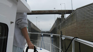 To enter the lake we had to go through a lock with a 57 foot lift. Joe called the lock tender as we arrived and almost immediately we were given permission to enter. We locked up all by ourselves. It was a little spooky. The lock walls are much higher than they needed to be to lift us to the lake level. Once we reached the higher level and heard the signal to leave, we were still well below the top of the walls and so had never been able to see anyone.
  Immediately after leaving the lock we arrived at the marina and were greated by fellow loopers. Happy Hour was to be at five at the gazebo - besides Carolyn Ann, there were fifteen other looper boats here. A mini-rendevous!
We'll stay here a few days. Joe is having the boat pulled to check for damage from whatever we hit while trying to anchor. During the down time we need to firm up our plans. From here we could follow the Cumberland which is navigable for about 380 miles to Celina, TN. Another option is follow the Tennessee River which is navigable for about 650 miles to Knoxville. We've got about two months before we can be south of 32 degrees latitude (about Demopolis, AL) for insurance reasons, so we'll probably do at least some of both rivers before continuing south.
Immediately after leaving the lock we arrived at the marina and were greated by fellow loopers. Happy Hour was to be at five at the gazebo - besides Carolyn Ann, there were fifteen other looper boats here. A mini-rendevous!
We'll stay here a few days. Joe is having the boat pulled to check for damage from whatever we hit while trying to anchor. During the down time we need to firm up our plans. From here we could follow the Cumberland which is navigable for about 380 miles to Celina, TN. Another option is follow the Tennessee River which is navigable for about 650 miles to Knoxville. We've got about two months before we can be south of 32 degrees latitude (about Demopolis, AL) for insurance reasons, so we'll probably do at least some of both rivers before continuing south.
If you'd like to see more pictures, follow the link to our picasa albums:
http://picasaweb.google.com/joseph.pica
We stopped for the night about halfway to the infamous asian carp barrier. The American Great Loop Cruisers Association had gotten involved in at least trying to somewhat schedule boats going through so there would not be a big pile up on the river. They had also negotiated a discount - now it would only cost us $495.  Because of the numbers planning to go through on Thursday and Friday, we decided to move our crossing up to Wednesday. As we started down toward the barrier, Joe received an email from his contact - affectionately known as Dr. Carp. He said that it looked like the restrictions would be easing significantly in the near future. Then the Coast Guard had a posting extending the current restrictions to September 18. At that point we were committed to going on through. The option would be to pay for dockage while we waited, which could end up being more than the tow charge. As we arrived at the barrier, the tug was just leaving with Theresa, another looper boat. We waited for it to come back, donned our life jackets (Rocky included), shut off Carolyn Ann's electrical system, and boarded the tug for the ten to fifteen minute ride through the barrier. Our trip was uneventful and we were on our way again after an hour and a half, including wait time. So, that was Wednesday. Friday they announced that beginning Saturday the tow would not be required. Once again, timing is everything.

After clearing the barrier, we came to the first of the big locks on the rivers. This one was a forty foot drop with floating bollards to tie to. The locks here are huge to accommodate the tugs and their barges. We came into this lock by ourselves and were told to go about halfway up. The tender said he'd normally have us go farther, but the dead deer that was floating near the exit had become pretty ripe.
We met up with Theresa - Bob and Theresa Kirkpatrick - in Joliet and tied up behind them on the free wall there. We spent a pleasant evening with them comparing notes on the fish barrier and the dead deer.
 The next morning as we headed south, we found that there was more along the river than just industry, tugs and barges. We were reminded of Joe's old hunting days - and also that summer was really over - when we saw a goose hunter on the river.
 There were lots of blinds. Joe was really impressed by some of them.
 We spent the night on a free wall in Ottawa - with free power. Illinois has been hit hard by the poor economy and it was evident along the river in Ottawa. They've built a nice riverwalk area with benches, but the landscaping is suffering from neglect to the point that some benches are unusable. It looks like a nice town, just a bit tired.
 We left early the next morning in fog that didn't hang around too long. It isn't a place you really want to be in fog. The tugs are pushing loads of barges that are often three barges across and five long. Their visibility often isn't that good - plus, it won't hurt them to hit you!
  Along this part of the river we started to feel like we were back on the Hudson with the Palisades.
From the Starved Rock Lock, we could see the high cliffs in the background - and if you look closely, you can see the heron supervising our locking.
 We all hear about the changeable conditions on these rivers - either flooding or drought. Judging by these trees, we guessed that the water is on the low side. The bridges in this area are generally high enough for us to pass under, but we had been annoyed earlier by the lack of clearance gauges on some bridges that we'd be close on.
  Our next stop was the Illinois Valley Yacht Club (IVY Club) near Peoria. Joe has family there and we’d planned to stop for a visit, but it’s a great place to stop if you’re in the area.
  It is probably the nicest facility we’ve been to and the price was good. Everything was clean – nice restaurant (white tablecloths!) and bar and a pool. The first order of business when we arrived was to do a quick clean up of all of Carolyn Ann’s exterior, horizontal surfaces. When we’d gone through the fish barrier, the tugs smoke stacks pointed right at her and left a fine black coating on everything. They didn’t charge extra for that.
Soon after we arrived, Joe’s cousin Danny and his wife Sylvia arrived to drop off a car for us to use for the weekend – thanks, guys! We ran some errands on Saturday – got lost in a section of Peoria Heights with mansions overlooking the river – that was fun.
It is probably the nicest facility we’ve been to and the price was good. Everything was clean – nice restaurant (white tablecloths!) and bar and a pool. The first order of business when we arrived was to do a quick clean up of all of Carolyn Ann’s exterior, horizontal surfaces. When we’d gone through the fish barrier, the tugs smoke stacks pointed right at her and left a fine black coating on everything. They didn’t charge extra for that.
Soon after we arrived, Joe’s cousin Danny and his wife Sylvia arrived to drop off a car for us to use for the weekend – thanks, guys! We ran some errands on Saturday – got lost in a section of Peoria Heights with mansions overlooking the river – that was fun.  Sunday we drove to the old family farm about an hour away. Joe’s Aunt Kay – who’s about to have a birthday, but don’t tell anyone – hosted a big family get together for us. Another aunt and uncle were there along with several more cousins and some of their children, unfortunately several had left before we got around to the group shot. Rocky wore himself out trying to play with Peaches – the cutest Yorky mix ever! After too much food and lots of stories – some of which we’d never heard – about half of the group came back to Peoria with us for the mandatory boat tour. We don’t see any of these folks often enough – hope they enjoyed it as much as we did!
 After leaving Peoria, we continued down the Illinois until it joined the Mississippi. One of the early sights on the Mississippi is St. Louis, MO. Unfortunately, there is no good place to stop there. We got a good look at the arch as we passed by – along with lots of open space just made for a non-existent city docks.
  We’d heard that the 218 miles we’d spend on the Mississippi was to be endured rather than enjoyed. We didn’t find that at all. The shoreline varies – sometimes high rocky cliffs and sometimes the low, flatter shoreline we’d expected. There is a lot of barge traffic and the water wasn’t that clear, turquoise we’d seen in the lake, but there were interesting sights. One good thing is the strong current.
  Our normal cruising speed of about 9 mph was boosted to 14 mph and we could see evidence of the debris that poses a hazard in high water, but we didn’t really experience any of that.
  We did go through turbulent areas with swirling whirlpools, though. Another problem with the Mississippi is the lack of good anchorages or marinas. We anchored near the end of our Mississippi run at a place called Angelo Towhead – basically an oxbow behind an island. We could see deadheads poking up – big branches that have gotten stuck on the bottom – but avoided them. Unfortunately there was evidently one stuck on the bottom that didn’t make it up to the surface. It made an awful noise as the prop chopped at it. We moved out to a slightly more exposed area to anchor and so far there has been no obvious negative impact.
We left the Mississippi where it intersects with the Ohio. For our sixty miles on the Ohio we were going up river which reduced our speed to about 7 mph. We had to go through two locks on the Ohio to be raised up this time. The first went fine, but our run of luck ended when we reached the second – Lock #52. As we arrived we were informed that it would be at a two to three hour wait.
We did go through turbulent areas with swirling whirlpools, though. Another problem with the Mississippi is the lack of good anchorages or marinas. We anchored near the end of our Mississippi run at a place called Angelo Towhead – basically an oxbow behind an island. We could see deadheads poking up – big branches that have gotten stuck on the bottom – but avoided them. Unfortunately there was evidently one stuck on the bottom that didn’t make it up to the surface. It made an awful noise as the prop chopped at it. We moved out to a slightly more exposed area to anchor and so far there has been no obvious negative impact.
We left the Mississippi where it intersects with the Ohio. For our sixty miles on the Ohio we were going up river which reduced our speed to about 7 mph. We had to go through two locks on the Ohio to be raised up this time. The first went fine, but our run of luck ended when we reached the second – Lock #52. As we arrived we were informed that it would be at a two to three hour wait.  We later learned that this is the busiest lock in the US. Barges can come to and from Lake Michigan or the Gulf of Mexico or as far as Pittsburgh to the east. These locks have two chambers – a 600’ foot one and a 1200’ one. The day we were there the smaller one was not in service. The tugs push barges that are lashed together – we saw them as big as five across and six long.
  They even make tugs with cockpits that can be raised and lowered. Up so they can see past their load, down to fit under bridges. When both locks are working, if traffic backs up, some of the loads will be broken down and taken through the smaller lock in stages. Since they couldn’t do that, traffic was really backing up – and the commercial traffic takes priority over pleasure craft. So we moved out of the channel, dropped the anchor and had lunch. The lock tender was as accommodating as possible – calling us once to say he’d fit us in the next lock, only to call back and say it wasn’t going to work. Finally he called and said that they needed to lock the work crew up in the small chamber and that we could go up with them. As it turned out, it had only taken us three hours. As we proceeded up the river, we saw miles of tugs with their barges parked along the shores waiting their turns.
 We found a nice anchorage behind another island just before the Cumberland River intersects the Ohio and managed to miss any hiding obstacles. Early in the evening, Joe called me to come outside. There was a squirrel swimming across to the island. Its fluffy tail just laid on the water surface. We didn’t even know they could swim. Later Joe saw him swim back. Guess that island wasn’t as good as it looked.
The next morning we started up the Cumberland – another up river trek. This time our speed dropped to about 5.5 mph. Our destination for the day, Green Turtle Bay Marina on Lake Barkley, was only about thirty miles up the river, but it took us about six hours. We did not encounter barge traffic on this leg, though, so it was a pleasant trip through the mostly rural area.
We found a nice anchorage behind another island just before the Cumberland River intersects the Ohio and managed to miss any hiding obstacles. Early in the evening, Joe called me to come outside. There was a squirrel swimming across to the island. Its fluffy tail just laid on the water surface. We didn’t even know they could swim. Later Joe saw him swim back. Guess that island wasn’t as good as it looked.
The next morning we started up the Cumberland – another up river trek. This time our speed dropped to about 5.5 mph. Our destination for the day, Green Turtle Bay Marina on Lake Barkley, was only about thirty miles up the river, but it took us about six hours. We did not encounter barge traffic on this leg, though, so it was a pleasant trip through the mostly rural area.  To enter the lake we had to go through a lock with a 57 foot lift. Joe called the lock tender as we arrived and almost immediately we were given permission to enter. We locked up all by ourselves. It was a little spooky. The lock walls are much higher than they needed to be to lift us to the lake level. Once we reached the higher level and heard the signal to leave, we were still well below the top of the walls and so had never been able to see anyone.
  Immediately after leaving the lock we arrived at the marina and were greated by fellow loopers. Happy Hour was to be at five at the gazebo - besides Carolyn Ann, there were fifteen other looper boats here. A mini-rendevous!
We'll stay here a few days. Joe is having the boat pulled to check for damage from whatever we hit while trying to anchor. During the down time we need to firm up our plans. From here we could follow the Cumberland which is navigable for about 380 miles to Celina, TN. Another option is follow the Tennessee River which is navigable for about 650 miles to Knoxville. We've got about two months before we can be south of 32 degrees latitude (about Demopolis, AL) for insurance reasons, so we'll probably do at least some of both rivers before continuing south.
Immediately after leaving the lock we arrived at the marina and were greated by fellow loopers. Happy Hour was to be at five at the gazebo - besides Carolyn Ann, there were fifteen other looper boats here. A mini-rendevous!
We'll stay here a few days. Joe is having the boat pulled to check for damage from whatever we hit while trying to anchor. During the down time we need to firm up our plans. From here we could follow the Cumberland which is navigable for about 380 miles to Celina, TN. Another option is follow the Tennessee River which is navigable for about 650 miles to Knoxville. We've got about two months before we can be south of 32 degrees latitude (about Demopolis, AL) for insurance reasons, so we'll probably do at least some of both rivers before continuing south.
No comments:
Post a Comment